GEN 3.2 Aeronautical charts
1 Responsible service(s)
1.1 The Civil Aviation Authority of South Africa provides a wide range of aeronautical charts for use by all types of civil aviation. The Aeronautical Information Service produces the charts which are part of the AlP.
1.2 The World aeronautical Chart (WAC) series ICAO 1: 1000 000 and ICAO 1:500 000 are compiled by the Department: Rural development and Land Reform, Chief Directorate: Nationale Geo-spatial Information.
1.3 Charts, suitable for pre-flight planning and briefing. selected from those listed In the ICAO Aeronautical Chart Catalogue (DOC 7101). are available for reference at aerodrome AIS units. (Their addresses can be found under para. 3 below.) The charts are produced in accordance with the provisions contained in ICAO Annex 4 - Aeronautical Charts. Differences to these provisions are detailed in subsection GEN 1.7.
2 Maintenance of charts
2.1 The aeronautical charts included in the AlP are kept up to date by amendments to the AIP. Corrections to aeronautical charts not contained in the AlP are promulgated by AIP amendments and are listed under paragraph 7 of this subsection. Information concerning the planning for or issuance of new maps and charts is notified by Aeronautical Information Circular.
2.2 If incorrect information detected on published charts is of operational significance, it is corrected by NOTAM.
3 Purchase arrangements
3.1 The following charts are available either flat or folded to ICAO specifications, from:
a) Department: Rural development and Land Reform
Chief Directorate: Nationale Geo-spatial Information
Private Bag X10
Mowbray
7705
Chief Directorate: Nationale Geo-spatial Information
Private Bag X10
Mowbray
7705
b) The Surveyor-General
Private Bag X20634
Bloemfontein
9300
Private Bag X20634
Bloemfontein
9300
c) The Surveyor-General
PO Box 396
Pietermaritzburg
3200
PO Box 396
Pietermaritzburg
3200
Note: Only a limited number of local 1:500 000 and 1:1 000 000 aeronautical charts are available from the offices of the Surveyor-General.
1) World Aeronautical Chart ICAO 1:1 000 000
2) SA Topo 1:500 000 (Aeronautical)
3.2 The following series of aeronautical charts are produced
a) World Aeronautical Chart - ICAO 1:1 000 000 (Mandatory)
b) Aeronautical Chart - ICAO: 1:500 000 (Non-mandatory)
c) Aerodrome/Heliport Chart - ICAO (Mandatory)
d) Aerodrome Ground Movement Chart - ICAO (Non-mandatory)
e) Aircraft Parking/Docking Chart -ICAO (Non-mandatory)
f) Standard Departure Chart -Instrument (SID) - ICAO (Conditionally required)
g) Standard Arrival Chart - Instrument (STAR) -ICAO (Conditionally required)
h) Instrument Approach Chart -ICAO (for each runway and procedure type) (Mandatory)
i) Precision Approach Terrain Chart (PATC) – ICAO (Mandatory)
j) Aerodrome Obstacle Chart - ICAO – Type A (Operating Limitations) (Mandatory)
k) Radar Minimum Altitude Chart (ATC Surveillance Minimum Chart) - ICAO
3.3 General description
a) World Aeronautical Chart -ICAO 1:1 000 000. This series is constructed on Lambert conical orthomorphic projection. The aeronautical data shown have been kept to a minimum, consistent with the use of the chart for visual air navigation. It includes a selection of aerodromes, significant obstacles, elements of the ATS system, prohibited, restricted and danger areas, and radio navigation aids. The chart provides information to satisfy visual air navigation and is also used as a pre-flight planning chart.
b) Aeronautical chart - ICAO 1: 500 000: This series is constructed on Lambert conical orthomorphic projection and the aeronautical data consist of major
international aerodromes, selected radio navigation aids, lattices of long-range electronic aids to navigation, FIR, CTA, CTR, reporting points, etc. The chart is designed to provide a means of maintaining a continuous flight record of the aircraft position.
international aerodromes, selected radio navigation aids, lattices of long-range electronic aids to navigation, FIR, CTA, CTR, reporting points, etc. The chart is designed to provide a means of maintaining a continuous flight record of the aircraft position.
c) Aerodrome/Heliport Chart - ICAO. This chart contains detailed aerodrome/heliport data to provide flight crews with information that will facilitate the ground movement of aircraft:
– from the aircraft stand to the runway; and;
– from the runway to the aircraft stand;
and helicopter movement:
from the helicopter stand to the touchdown and lift-off area and to the final approach and take-off area;
and helicopter movement:
from the helicopter stand to the touchdown and lift-off area and to the final approach and take-off area;
– from the final approach and take-off area to the touchdown and lift-off area and to the helicopter stand;
– along helicopter ground and air taxiways; and
– along air transit routes.
It also provides essential operational information at the aerodrome/heliport.
It also provides essential operational information at the aerodrome/heliport.
d) Aerodrome Ground Movement Chart - ICAO. This chart is produced for those aerodromes where, due to congestion of information, details necessary for the ground movement of aircraft along the taxiways to and from the aircraft stands and for the parking/docking of aircraft cannot be shown with sufficient clarity on the Aerodrome/Heliport Chart - ICAO.
e) Aircraft Parking/Docking Chart - ICAO. This chart is produced for those aerodromes where, due to the complexity of the terminal facilities, the information to facilitate the ground movement of aircraft between the taxiways and the aircraft stands and the parking/docking of aircraft cannot be shown with sufficient clarity on the Aerodrome/Heliport Chart - ICAO or on the Aerodrome Ground Movement Chart - ICAO.
f) Standard Departure Chart - Instrument (SID) - ICAO. This chart is produced whenever a standard departure route - instrument has been established and cannot be shown with sufficient clarity on the Area Chart - ICAO. The aeronautical data shown includes the aerodrome of departure, aerodrome(s) which affect the designated standard departure route - instrument, prohibited, restricted and danger areas and the air traffic services system. This chart provides the flight crew with information that will enable them to comply with the designated standard departure route - instrument from the take-off phase to the en-route phase.
g) Standard Arrival Chart - Instrument (STAR) - ICAO. This chart is produced whenever a standard arrival route - instrument has been established and cannot be shown with sufficient clarity on the Area Chart - ICAO.
The aeronautical data shown include the aerodrome of landing, aerodrome(s) which affect the designated standard arrival route - instrument, prohibited, restricted and danger areas and the air traffic services system. This chart provides the flight crew with information that will enable them to comply with the designated standard arrival route - instrument from the en-route phase to the approach phase.
The aeronautical data shown include the aerodrome of landing, aerodrome(s) which affect the designated standard arrival route - instrument, prohibited, restricted and danger areas and the air traffic services system. This chart provides the flight crew with information that will enable them to comply with the designated standard arrival route - instrument from the en-route phase to the approach phase.
h) Instrument Approach Chart - ICAO. This chart is produced for all aerodromes used by civil aviation where instrument approach procedures have been established. A separate Instrument Approach Chart - ICAO has been provided for each approach procedure.
The aeronautical data shown includes information on aerodromes, prohibited, restricted and danger areas, radio communication facilities and navigation aids, minimum sector altitude, procedure track portrayed in plan and profile view, aerodrome operating minima etc.
This chart provides the flight crew with information that will enable them to perform an approved instrument approach procedure to the runway of intended landing including the missed approach procedure and where applicable, associated holding patterns.
i) Precision Approach Terrain Chart – ICAO. This chart provides detailed terrain profile information within a defined portion of the final approach so as to enable the aircraft operating agencies to assess the effects of the terrain on decision height determination by use of radio altimeters.
j) Aerodrome Obstacle Chart – ICAO Type A (Operating Limitations). This chart is produced for all aerodromes used by civil aviation, and provides information on significant obstacles in the take-off flight path areas. It is shown in both plan and profile view. This obstacle information provides data necessary to enable the operator to comply with the operating limitations of Annex 6, Parts I and II, Chapter 5.
k) Radar Minimum Altitude Chart (ATC Surveillance Minimum Chart) - ICAO. This supplementary chart provides information which enables the flight crew to monitor and cross-check altitudes assigned by a controller using an ATS surveillance system.
3.4 The following series of charts are not published/produced: These charts are either not required, not implementedor are available from commercial suppliers.
a) Aeronautical Navigation Chart - ICAO Small Scale
b) Plotting Chart - ICAO
c) Aerodrome Obstacle Chart - ICAO Type B
d) Aerodrome Terrain and Obstacle Chart - ICAO Electronic
e) Area Chart - ICAO
f) Enroute Chart - ICAO
g) Visual Approach Chart - ICAO
h) Electronic Aeronautical Chart Display - ICAO Charts
4 List of aeronautical charts available
4.1 The aeronautical charts available are listed in the tables which follow at 5.
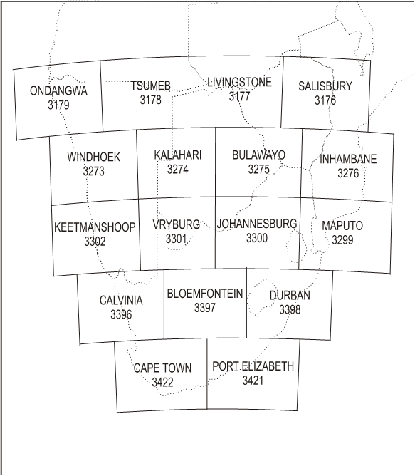
5 Index to the World Aeronautical Chart (WAC) - ICAO 1: 1000
| Title of Series | Scale | Name and/or number | Date Y/M/D | Source Date | ||
|---|---|---|---|---|---|---|
| World Aeronautical Chart ICAO (WAC) | 1:10 00 000 | Bloemfontein Bulawayo Calvinia Cape Town Durban Inhambane Johannesburg Kalahari Keetmanshoop Livingstone Maputo Ondangwa Port Elizabeth Tsumeb Vryburg Windhoek |
(3397) (3275) (3396) (3422) (3398) (3276) (3300) (3274) (3302) (3177) (3299) (3179) (3421) (3178) (3301) (3273) |
7th Ed 4th Ed 6th Ed 5th Ed 8th Ed 4th Ed 7th Ed 3rd Ed 4th Ed 5th Ed 5th Ed 3rd Ed 4th Ed 4th Ed 6th Ed 4th Ed |
OCT 17 DEC 16 DEC 16 DEC 16 OCT 17 DEC 12 OCT 17 NOV 16 MAY 14 MAY 14 DEC 16 MAY 14 OCT 17 MAY 14 OCT 17 MAY 14 |
2006 2006 2006 2006 2006 2000 2006 1998 2002 2009 2006 2009 1998 2009 2006 2009 |
| SA Topographical Aeronautical Edition | 1:50 0 000 | Alexander Bay Alldays Beaufort West Bloemfontein Calvinia Cape Town Gobabis Grootfontein Johannesburg Katima Mulilo Keetmanshoop Kimberley Kroonstad Leonardville Luderitz Nelspruit Ondangwa Opuwo Otjiwarongo Oudtshoorn Musina Phalaborwa Polokwane Port Elizabeth Prieska Queenstown Rehoboth Rundu Springbok Ulundi Upington Vryburg Windhoek |
(2714) (2126) (3122) (2924) (3117) (3317) (2118) (1918) (2526) (1722) (2518) (2722) (2726) (2318) (2514) (2530) (1714) (1711) (1914) (3320) (2130) (2330) (2326) (3324) (2920) (3126) (2314) (1718) (2916) (2730) (2718) (2522) (2113)( |
5th Ed 3rd Ed 4th Ed 3rd Ed 2nd Ed 4th Ed 1st Ed 1st Ed 4th Ed 1st Ed 3rd Ed 2nd Ed 3rd Ed 1st Ed 1st Ed 4th Ed 1st Ed 1st Ed 2nd Ed 4th Ed 3rd Ed 4th Ed 3rd Ed 2nd Ed 4th Ed 2nd Ed 1st Ed 1st Ed 5th Ed 3rd Ed 4th Ed 3rd Ed 1st Ed |
DEC 15 MAR 18 DEC 15 DEC 15 APR 18 MAR 18 Namib FEB 00 Namib May 96 MAR 18 RSA OCT 95 DEC 15 JUN 16 AUG 16 Namib FEB 00 Namib JAN 03 MAR 18 JUN 96 FEB 00 FEB 00 DEC 15 MAR 18 MAR 18 JUN 16 OCT 15 JUN 16 AUG 16 OCT 98 OCT 96 JUN 16 AUG 16 DEC 15 DEC 15 OCT 99 |
2009 2001 2005 2004 2000 2014 1985 1985 2015 1982 2009 2002 2000 1983 1978 2010 1981 1985 1986 2007 1999 2008 2001 1998 2005 1992 1977 1981 2003 2000 2009 2007 1984 |
| Title of Series | Scale | Date Y/M/D |
Source Date | |||
|---|---|---|---|---|---|---|
| Instrument Approach and landing Chart | Alexander Bay Aerodrome Chart VOR-A RWY 01 VOR-B RWY 19 |
- AD-01 -VOR-01 -VOR-02 |
07/03/15 07/03/15 07/03/15 |
|||
| Bethlehem Aerodrome Chart |
-AD-01 |
07/06/07 |
||||
| Bloemfontein (Bram Fischer INTL) Aerodrome Chart Aircraft parking/Docking chart Hot Spot VOR RWY 02 VOR RWY 20 Radar Terrain Clearance Chart UTONU 1A STAR 02 Data tabulation OKTIG 1B SID 02 Data tabulation RNAV (GNSS) RWY 02 Data tabulation RNAV (GNSS) RWY 20 Data tabulation |
-AD-01 -AD-02 -AD-03 -VOR-01 -VOR-02 -RAD-01 -ARR-01 -ARR-01A -DEP-01 -DEP-01A -RNAV-01 -RNAV-01A -RNAV-02 -RNAV-02A |
18/11/08 14/11/13 17/01/05 14/12/11 14/12/11 14/04/03 17/03/30 17/03/30 17/03/30 17/03/30 17/03/30 17/03/30 17/03/30 17/03/30 |
|
|||
| Bhisho Aerodrome Chart |
-AD-01 |
18/12/06 |
||||
| Cape Town INTL Aerodrome Chart Ground Movement Chart Docking Chart Docking Chart Restricted Visibility Chart Hot Spot Helicopters ARR/DEP Zone |
-AD-01 -AD-02 -AD-03 -AD-04 -AD-05 -AD-06 -AD-07 |
19/06/20 17/11/09 15/01/08 12/11/15 11/11/17 14/02/06 12/03/08 |
||||
| TETAN lC SID 01 KODES 1A SID 01 IMSOM 1A SID 01 OKTED 1A SID 01 TETAN 1A SID 19 TETAN 1B SID 19 KODES 1B SID 19 IMSOM 1B SID 19 OKTED 1B SID 19 OKTED 1C SID 19 ERDAS1A STAR 01 GETEN1A STAR 01 ROBBENISLAND 4C STAR 01 ASPIK 1A STAR 01 RWY 01 EVUKI 1A ERDAS 1B STAR 19 GETEN 19 STAR 19 ASPIK 1B STAR 19 EVUKI 1B STAR 19 |
-DEP-01 -DEP-02 -DEP-03 -DEP-04 -DEP-05 -DEP-06 -DEP-07 -DEP-08 -DEP-09 -DEP-10 -ARR-01 -ARR-02 -ARR-03 -ARR-04 -ARR-05 -ARR-06 -ARR-07 -ARR-08 -ARR-09 |
19/01/03 19/01/03 07/05/10 19/01/03 19/01/03 19/01/03 19/01/03 07/05/10 19/01/03 19/01/03 19/01/03 19/01/03 07/05/10 07/05/10 08/06/05 19/01/03 19/01/03 07/05/10 07/05/10 |
|
|||
| IILS RWY 01 ILS Z RWY 19 ILS Y RWY 19 VOR Z RWY 01 VOR RWY 19 VOR Y RWY 01 Radar Terrain Clearance Chart Precision APCH Terrain Chart RWY 01 Precision APCH Terrain Chart RWY 19 AD OBST Type A AD OBST Type A RNAV (RNP) Z RWY 01 Data tabulation RNAV (RNP) Y RWY 01 Data tabulation RNAV (RNP) Z RWY 19 Data tabulation RNAV (RNP) Z RWY 34 Data tabulation RNAV (GNSS) RWY 01 Data tabulation RNAV (GNSS) RWY 19 Data tabulation |
-ILS-01 -ILS-02 -ILS-03 -VOR-01 -VOR-02 -VOR-03 -RAD-01 -PATC-01 -PATC-02 -OBST TYPE A-01 -OBST Type A-02 -RNAV-01 -RNAV-01A -RNAV-02 -RNAV-02A -RNAV-03 -RNAV-03A -RNAV-04 -RNAV-04A -RNAV-05 -RNAV-05A -RNAV-06 -RNAV-06A |
07/05/10 07/05/10 07/05/10 19/01/03 07/05/10 07/05/10 07/05/10 13/10/17 13/10/17 13/10/17 13/10/17 19/05/23 17/10/12 19/05/23 17/10/12 19/01/03 17/10/12 19/05/23 17/11/09 19/05/23 20/03/26 18/05/24 18/02/01 |
||||
| East London Aerodrome Chart Restricted Visibility Chart ILS Z RWY 11 ILS RWY 29 VOR RWY 11 VOR Z RWY 29 VOR Y RWY 29 Radar Terrain Clearance Chart RNAV (GNSS) RWY 11 Data tabulation RNAV (GNSS) RWY 29 Data tabulation |
-AD-01 -AD-02 -ILS-01 -ILS-03 -VOR-01 -VOR-02 -VOR-03 -RAD-01 -RNAV-01 -RNAV-01A -RNAV-02 -RNAV-02A |
18/10/11 16/12/08 08/07/03 08/07/03 08/07/03 08/07/03 08/07/03 07/07/05 18/10/11 17/07/20 17/07/20 17/07/20 |
|
|||
| Fort Beaufort Aerodrome Chart RNAV (GNSS) RWY 11 Data tabulation RNAV (GNSS) RWY 29 Data tabulation |
-AD-01 -RNAV-01 -RNAV-01A -RNAV-02 -RNAV-02A |
18/10/11 18/03/01 18/03/01 18/03/01 18/03/01 |
||||
| Graaff-Reinet Aerodrome Chart RNAV (GNSS) RWY 04 Data tabulation |
-AD-01 -RNAV-01 -RNAV-01A |
21/08/12 21/02/25 21/02/25 |
||||
| George Aerodrome Chart Restricted visibility chart Hot Spot XALIN 1B RNAV (GNSS) RWY 11 STAR Data tabulation AXEMU 1A RNAV (GNSS) RWY 11 Data tabulation GABGO 1A RNAV (GNSS) RWY 11 STAR Data tabulation GABGO 1B RNAV (GNSS) RWY 11 STAR Data tabulation |
-AD-01 -AD-02 -AD-03 -ARR-02 -ARR-02A -ARR-03 -ARR-03A -ARR-04 -ARR-04A -ARR-05 -ARR-05A |
18/10/11 18/05/24 18/05/24 18/05/24 18/05/24 18/05/24 18/05/24 18/05/24 18/05/24 18/05/24 18/05/24 / |
||||
| Instrument Approach and landing Chart | ILS RWY 11 ILS Z RWY 29 VOR RWY 11 VOR RWY 29 Radar Minimum Altitude Chart RNAV (GNSS) RWY 11 Data tabulation RNAV (GNSS) RWY 29 Data tabulation P-APCH Terrain Chart RWY 06 P-APCH Terrain Chart RWY 24 AD OBST Type A |
--ILS-01 -ILS-02 -VOR-01 -VOR-02 -RAD-01 -RNAV-01 -RNAV-01A -RNAV-02 -RNAV-02A -PATC-01 -PATC-02 -OBST Type A-01 |
16/05/26 16/11/10 14/05/01 14/05/01 13/01/10 18/02/01 18/03/29 18/03/29 18/03/29 16/11/10 16/11/10 16/11/10 |
|||
| George Dick Montshioa Aerodrome Chart VOR A RWY 04 |
-AD-01 -VOR-01 |
19/07/18 19/06/20 |
||||
| Grand Central Aerodrome Chart Restricted visibility Chart |
-AD-02 |
19/07/18 10/04/08 |
||||
| Greytown Aerodrome Chart VOR RWY 24 RNAV (GNSS) RWY 24 Data tabulation |
-AD-01 -VOR-01 -RNAV-01 -RNAV-01A |
21/08/12 19/03/28 19/05/23 19/05/23 |
||||
| Hluhluwe Aerodrome Chart |
|
04/07/08 |
||||
| Hoedspruit Aerodrome Chart Radar Terrain Clearance Chart VOR/DME/ILS 18 VOR/DME 18 VOR/DME 36 VOR/DME 36 |
-AD-01 -RAD-01 -ILS-01 -VOR-01 -VOR-02 -VOR-03 |
4/07/08 06/08/03 15/05/28 04/07/08 04/07/08 04/07/08 |
||||
| Johannesburg (O R Tambo INTL) Aerodrome Chart Ground movement Aircraft Parking/Docking Chart Aerodrome Parking and Docking Chart Aircraft Parking/Docking Chart Aircraft Parking/Docking Chart Ground Movement Chart - A380 Hot spot chart EGMEN 2A SID 03L APDAK 3A RWY 03L SID VASUR 3A SID 03L/R RAGUL 3A RWY 03L/R SID OVALA 1A RWY 03L/R SID NESAN 1A SID 03L/R GRASMERE 5B RWY 03L/R SID EXOBI lA SID 03L/R NORVA 2A RWY 03L/R SID EGMEN 1C SID 03L |
-AD-01 -AD-02 -AD-03 -AD-04 -AD-05 -AD-06 -AD-07 -AD-08 -DEP-01 -DEP-02 -DEP-03 -DEP04 -DEP-05 -DEP-06 -DEP-07 -DEP-08 -DEP-09 -DEP-10 |
18/10/11 16/02/04 18/01/04 18/01/04 18/01/04 15/04/30 16/08/18 16/02/04 13/01/10 16/08/18 16/03/31 16/08/18 16/08/18 13/01/10 17/07/20 13/01/10 16/08/18 13/01/10 |
||||
| Instrument Approach and Landing Chart | Data tabulation APDAK 1 B RNAV 03L SID Data tabulation EGMEN 2B SID 21R APDAK 2B RWY 21R SID VASUR 3B SID 21L/R RAGUL 3B RWY 21L/R SID OVALA 1B RWY 21L/R SID GRASMERE 6C RWY 21R SID EXOSI 3B SID 21L/R HEIDELBERG 5D RWY 21L/R SID LANSERIA 1C SID 21R EGMEN 1D SID 21R Data tabulation APDAK 1 D RNAV RWY 21R SID Data tabulation GEROX 1C RNAV RWY 21R SID Data tabulation AVAGO 2A 03 STAR NIBEX 2A 03R STAR STANDERTON 6A 03R STAR OKPIT 4A 03R STAR WITBANK 4A 03R STAR AVILO 1A 03R STAR AVAGO 1C 03R STAR Data tabulation NIBEX 1B RNAV RWY 03R STAR Data tabulation STANDERTON 1C RNAV RWY 03R STAR Data tabulation AVILO 1B RNAV RWY 03R STAR Data tabulation AVAGO 2B STAR 21 NIBEX 2C RWY 21L STANDERTON 5B STAR 21L OKPIT 4B STAR 21L WITBANK 3C STAR 21L AVAGO 1D STAR 21L Data tabulation NIBEX 1D STAR 21L Data tabulation STANDERTON 1D STAR 21L Data tabulation ILS Z RWY 03L ILS Y RWY 03L ILS Z RWY 03R ILS X RWY 03R ILS W RWY 03R ILS Z RWY 21L ILS X RWY 21L ILS RWY 21R VOR Z RWY 21R VOR Y RWY 21R Radar Minimum Altitude Chart RNAV RWY 03R Data tabulation RNAV RWY 21L Data tabulation AD OBST Type A RWY 03L 21R AD OBST Type A RWY 03R 21L |
-DEP-10A -DEP-11 -DEP-11A -DEP-12 -DEP-13 -DEP-14 -DEP-15 -DEP-16 -DEP-17 -DEP-18 -DEP-19 -DEP-20 -DEP-21 -DEP-21A -DEP-22 -DEP-22A -DEP-23 -DEP-23A -ARR-01 -ARR-02 -ARR-03 -ARR-04 -ARR-05 -ARR-07 -ARR-08 -ARR-08A -ARR-09 -ARR-09A -ARR-10 -ARR-10A -ARR-12 -ARR-12A -ARR-13 -ARR-14 -ARR-15 -ARR-16 -ARR-17 -ARR-18 -ARR-18A -ARR-19 -ARR-19A -ARR-20 -ARR-20A -ILS-01 -ILS-02 -ILS-03 -ILS-05 -ILS-06 -ILS-07 -ILS-09 -ILS-10 -VOR-01 -VOR-02 -RAD-01 -RNAV-01 -RNAV-01A -RNAV-02 -RNAV-02A -OBST Type A-01 -OBST Type A-02 |
13/01/10 14/08/21 13/01/10 13/01/10 14/08/21 16/03/31 14/08/21 14/08/21 14/08/21 13/01/10 14/08/21 16/03/31 13/01/10 13/01/10 14/08/21 13/01/10 14/08/21 13/01/10 20/12/31 20/12/31 20/12/31 20/12/31 20/12/31 20/12/31 20/12/31 13/01/10 20/12/31 13/01/10 20/12/31 13/01/10 20/12/31 13/01/10 20/12/31 20/12/31 20/12/31 20/12/31 20/12/31 20/12/31 13/01/10 20/12/31 13/01/10 20/12/31 13/01/10 13/01/10 16/08/18 13/01/10 14/08/21 14/08/21 13/01/10 16/08/18 16/06/23 13/04/04 13/01/10 16/03/31 20/12/31 14/01/09 20/12/31 14/05/01 20/10/08 17/04/27 |
|
||
| Instrument Approach and Landing Chart | P-PCH Terrain Chart RWY 03L P-APCH Terrain Chart RWY 21R P-APCH Terrain Chart RWY 03R P-APCH Terrain Chart RWY 21L |
-PATC-01 -PATC-02 -PATC-03 -PATC-04 |
17/01/05 17/01/05 17/01/05 17/01/05 |
|
||
| Kimberly Aerodrome Chart Restricted Visibility Chart Aircraft Parking/Docking Chart VOR RWY 02 VOR RWY 20 EVESI 1A STAR 02 Data tabulation IBKEL 1A STAR 02 Data tabulation IBKEL 1B STAR 20 Data tabulation UNRAG 1A SID 02 Data tabulation RNAV (GNSS) RWY 02 Data tabulation RNAV (GNSS) RWY 20 Data tabulation |
-AD-01 -AD-02 -AD-03 -VOR-01 -VOR-02 -ARR-01 -ARR-01A -ARR-02 -ARR-02A -ARR-03 -ARR-03A -DEP-01 -DEP-01A -RNAV-01 -RNAV-01A -RNAV-02 -RNAV-02A |
21/02/25 12/11/15 18/01/04 13/12/12 13/12/12 17/05/25 17/05/25 20/08/13 20/08/13 20/08/13 20/08/13 17/05/25 17/05/25 17/06/22 17/06/22 17/06/22 17/06/22 |
||||
| Instrument Approach and Landing Chart | King Shaka INTL Aerodrome Chart Aircraft Parking/Docking Chart AD OBST TYPE A ILS Z RWY 06 ILS Y RWY 06 LS Z RWY 24 ILS Y RWY 24 VOR Z RWY 06 VOR Z RWY 24 Radar Minimum Altitude Chart RWY 06 APMAT 1A Data tabulation RWY 06 DUNSA 1A Data tabulation RWY 06 GETOK 1C Data tabulation RWY 06 ITMIL 1A Data tabulation RWY 24 APMAT 1B Data tabulation RWY 24 DUNSA 1B Data tabulation RWY GETOK 1D Data tabulation RWY24 ITMIL 1B Data tabulation RWY 06 ITMIL 1C Data tabulation RWY 24 OKTAN 1A Data tabulation RWY 06 TUBIN 1A Data tabulation RWY 24 TUBIN 1B Data tabulation Greytown 1A Data tabulation Greytown 2B Data tabulation RNAV RWY 06 |
-AD-01 -AD-02 -OBST Type A-01 -ILS-01 -ILS-02 -ILS-03 -ILS-04 -VOR-01 -VOR-02 -RAD-01 -ARR-01 -ARR-01A -ARR-02 -ARR-02A -ARR-03 -ARR-03A -ARR-04 -ARR-04A -ARR-05 -ARR-05A -ARR-06 -ARR-06A -ARR-07 -ARR-07A -ARR-08 -ARR-08A -DEP-01 -DEP-01A -DEP-02 -DEP-02A -DEP-03 -DEP-03A -DEP-04 -DEP-04A -DEP-05 -DEP-05A -DEP-06 -DEP-06A -RNAV-01 |
18/10/11 15/06/25 11/06/02 16/12/08 16/12/08 16/12/08 16/12/08 17/01/05 17/01/05 13/07/25 14/12/11 10/05/06 14/12/11 13/05/02 15/04/30 17/08/17 15/08/20 10/05/06 15/08/20 11/04/07 14/12/11 13/03/07 15/08/20 11/04/07 17/03/30 11/04/07 14/12/11 10/05/06 14/12/11 11/04/07 14/12/11 11/04/07 14/12/11 11/04/07 14/12/11 11/04/07 14/12/11 11/04/07 17/08/17 |
|||
| Instrument Approach and Landing Chart |
Data tabulation RNAV RWY 24 Data tabulation Precision APCH Terrain Chart RWY 06 Precision APCH Terrain Chart RWY 24 |
-RNAV-01A -RNAV-02 -RNAV-02A -PATC-01 -PATC-02 |
10/11/18 17/08/17 15/04/30 14/12/11 14/12/11 |
|||
| Kleinsee Aerodrome Chart |
-AD-01 |
04/07/08 |
||||
| Kruger Mpumalanga INTL Aerodrome Chart RAMP chart NDB RWY 05 NDB RWY 23 ILS Z RWY 05 ILS Y RWY 05 ILS X RWY 05 VOR/DME RWY 05 VOR/DME RWY 23 RNAV (GNSS) RWY 05 Data tabulation TILIR 1A Data tabulation |
-AD-01 -AD-02 -NDB-01 -NDB-02 -ILS-01 -ILS-02 -ILS-03 -VOR-01 -VOR-02 -RNAV-01 -RNAV-01A -ARR-01 -ARR-01A |
20/12/31 04/07/08 18/07/19 18/07/19 20/04/23 20/04/23 18/07/19 18/07/19 18/07/19 20/10/08 20/10/08 21/05/20 21/05/20 |
||||
| Ladysmith Aerodrome Chart VOR RWY 11/29 |
- AD-01 -VOR-01 |
04/07/08 09/12/17 |
||||
| Langebaan CFS Aerodrome Chart Bergriver SID Hopefield SID Bergriver STAR Hopefield STAR Radar Chart VOR/DME/ILS 20L VOR/DME 02R TACAN arc 02R VOR/DME or VOR 20L TACAN arc 20L |
-AD-01 -DEP-01 -DEP-02 -ARR-01 -ARR-02 -RAD-01 -ILS-01 -VOR-01 -VOR-02 -VOR-03 -VOR-04 |
04/07/08 04/08/05 04/08/05 04/08/05 04/08/05 06/08/03 15/09/17 04/07/08 04/07/08 04/07/08 04/07/08 |
||||
| Lanseria INTL Aerodrome chart Aicraft parking/Docking Chart Restricted Visibility Chart RNAV (GNSS) RWY 07 Data tabulation RNAV (RNP) RWY 25 Data tabulation VOR Z RWY 07 VOR Y RWY 07 ILS Z RWY 07 Data tabulation |
-AD-01 -AD-02 -AD-03 -RNAV-01 -RNAV-01A -RNAV-02 -RNAV-02A -VOR-01 -VOR-02 -ILS-01 -ILS-01A |
19/06/20 17/07/20 19/01/03 16/08/18 21/07/15 18/05/24 18/05/24 16/05/26 16/05/26 20/04/23 20/04/23 |
||||
| Makhado AFB Aerodrome Chart Radar Terrain Clearance VOR/DME/ILS 10 TACAN arc 10 TACAN arc 28 VOR/DME 10 |
-AD-01 -RAD-01 -ILS-01 -VOR-01 -VOR-02 -VOR-03 |
04/07/08 06/08/03 17/10/12 04/07/08 04/07/08 04/07/08 |
|
|||
| Margate Aerodrome Chart RNAV (GNSS) RWY 05 Data tabulation RNAV (GNSS) RWY 23 Data tabulation |
-AD-01 -RNAV-01 -RNAV-01A -RNAV-02 -RNAV-02A |
18/10/11 16/12/08 16/12/08 16/12/08 16/12/08 |
||||
| Majuba Power Station Aerodrome Chart |
-AD-01 |
04/07/08 |
||||
| Malelane Aerodrome Chart RNAV (GNSS) RWY 09 Data tabulation RNAV (GNSS) RWY 27 Data tabulation |
-AD-01 -RNAV-01 -RNAV-01A -RNAV-02 -RNAV-02A |
18/10/11 17/04/27 15/10/15 17/04/27 15/10/15 |
||||
| Mthatha Aerodrome Chart RNAV RWY 14 Data tabulation RNAV RWY 32 Data tabulation VOR RWY 14 VOR RWY 32 |
-AD-01 -RNAV-01 -RNAV-01A -RNAV-02 -RNAV-02A -VOR-01 -VOR-02 |
14/07/24 13/07/25 13/07/25 13/07/25 13/07/25 12/07/26 12/07/26 |
||||
| Nelspruit Aerodrome RAMP |
AD-01 AD-02 |
07/04/08 07/04/08 |
||||
| Newcastle Aerodrome Chart |
-AD-01 |
08/12/18 |
||||
| Oudtshoorn Aerodrome Chart |
-AD-01 |
07/10/25 |
||||
| Overberg Aerodrome Chart Radar Terrain Clearance Chart VOR/DME/ILS 35 VOR/DME 17 TACAN arc 17 VOR/DME 35 TACAN arc 35 RNAV (GNSS) RWY 17 Data tabulation RNAV (GNSS) RWY 35 Data tabulation |
--AD-01 -RAD-01 -ILS-01 -VOR-01 -VOR-02 -VOR-03 -VOR-04 -RNAV-01 -RNAV-01A -RNAV-02 -RNAV-02A |
04/07/08 06/08/03 15/07/23 04/07/08 04/07/08 04/07/08 04/07/08 04/07/08 18/03/29 18/05/24 18/03/29 |
|
|||
| Phalaborwa Aerodrome Chart Breakcloud VOR/NDB or VOR 19 |
--AD-01 -VOR-01 |
04/07/08 04/07/08 |
||||
| Pietermaritzburg Aerodrome Chart RNAV (GNSS) RWY 16 Data tabulation RNAV (GNSS) RWY 34 Data tabulation |
-AD-01 -RNAV-01 -RNAV-01A -RNAV-02 -RNAV-02A |
15/05/28 19/06/20 10/07/29 19/07/18 10/09/23 |
||||
| Piet Retief Aerodrome Chart |
-AD-01 |
04/07/08 |
||||
| Pilanesberg Aerodrome Chart Breakcloud VOR/DME 05 |
-AD-01 -VOR-01 |
04/07/08 04/07/08 |
||||
| Plettenberg Bay Aerodrome Chart RNAV (GNSS) RWY 12 Data tabulation RNAV (GNSS) RWY 30 Data tabulation |
-AD-01 -RNAV-01 -RNAV-01A -RNAV-02 -RNAV-02A |
11/01/08 |
||||
| Polokwane Intl Aerodrome Chart Restricted Visibility Chart VOR RWY 05 ILS RWY 05 RNAV (GNSS) RWY 05 Data tabulationj |
-AD-01 -AD-02 -VOR-01 -ILS-01 -RNAV-01 -RNAV-01A |
18/11/08 13/03/07 16/09/15 17/10/12 19/07/18 19/07/18 |
||||
| Pongola Aerodrome Chart |
-AD-01 |
04/07/08 |
||||
| Instrument Approach and Landing Chart | Port Elizabeth Aerodrome Chart Aircraft parking/Docking Chart ILS RWY 08 ILS Z RWY 26 VOR Z RWY 08 VOR Z RWY 26 Radar Terrain Clearance Chart RNAV (GNSS) RWY 08 Data tabulation RNAV (GNSS) RWY 26 Data tabulation AD OBST Type A-01 RWY 08/26 Precision APCH Terrain ChartRWY PrecisionAPCHTerrain ChartRWY 26 |
-AD-01 -AD-02 -ILS-01 -ILS-02 -VOR-01 -VOR-02 -RAD-01 -RNAV-01 -RNAV-01A -RNAV-02 -RNAV-02A -OBST Type A-01 -PATC-01 -PATC-02 |
18/11/08 15/09/17 17/09/14 17/09/14 18/12/06 16/01/07 13/04/04 15/09/17 15/09/17 15/09/17 15/09/17 18/06/21 18/06/21 18/06/21 |
|
||
| Rand Aerodrome Chart Restricted Visibility Chart |
-AD-01 -AD-02 |
18/01/11 10/01/14 |
||||
| Richards Bay Aerodrome Chart Parking Breakcloud VOR/DME 05 Breakcloud VOR 05 Breakcloud VOR/DME 23 Breakcloud VOR 2 |
-AD-01 -AD-02 -VOR-01 -VOR-02 -VOR-03 -VOR-04 |
04/07/08 04/07/08 04/07/08 04/07/08 04/07/08 04/07/08 |
||||
| Secunda Aerodrome Chart |
-AD-01 |
12/08/23 |
||||
| Sishen Aerodrome Chart Aircraft parking/Docking chart XASMI/XATKU VISUAL DEP XATKU/XASMI VISUAL ARR RNAV (GNSS) RWY 17 Data tabulation |
-AD-01 -AD-02 -VFR DEP-01 -VFR ARR-01 -RNAV-01 -RNAV-01A |
21/08/12 14/05/01 19/07/18 19/07/18 17/09/14 17/09/14 |
||||
| Skukuza Aerodrome Chart Breakcloud NDB 35 RNAV (GNSS) RWY 17 Data tabulation RNAV (GNSS) RWY 35 Data tabulation |
-AD-01 -NDB-01 -RNAV-01 -RNAV-01A -RNAV-02 -RNAV-02A |
18/12/06 04/0708 18/12/06 18/12/06 18/12/06 18/12/06 |
||||
| St Francis field RNAV (GNSS) RWY 10 Data tabulation RNAV (GNSS) RWY 28 Data tabulation |
-AD-01 -RNAV-01 -RNAV-01A -RNAV-02 -RNAV-02A |
18/12/06 18/09/13 18/09/13 18/09/13 18/09/13 |
||||
| Swartkop MIL Aerodrome Chart |
-AD-01 |
15/03/07 |
||||
| Tutuka Aerodrome Chart |
-AD-01 |
04/07/08 |
||||
| Instrument Approach and Landing Chart | Tswalu Aerodrome Chart NEXUP 1 A SID RWY 18 Data tabulation NEXUP 1 B SID RWY 36 Data tabulation RNAV (GNSS) RWY 18 Data tabulation RNAV (GNSS) RWY 36 Data tabulation |
-AD-01 -DEP-01 -DEP-01A -DEP-02 -DEP-02A -RNAV-01 -RNAV-01A -RNAV-02 -RNAV-02A |
19/01/03 15/09/17 15/09/17 15/09/17 15/09/17 18/10/11 15/09/17 15/09/17 15/09/17 |
|||
| Tzaneen Aerodrome Chart |
-AD-01 |
04/07/08 |
||||
| Ulundi Aerodrome Chart |
-AD-01 |
04/07/08 |
||||
| Instrument Approach and Landing Chart | Upington Aerodrome Chart Restricted Visibility Chart Hot spot chart VOR RWY 35 RNAV (GNSS) RWY 35 Data tabulation |
-AD-01 -AD-02 -AD-03 -VOR-01 -RNAV-01 -RNAV-01A |
21/08/12 14/05/01 16/01/07 14/03/06 16/12/08 16/12/08 |
|
||
| Venetia Mine Aerodrome Chart |
-AD-01 |
04/07/08 |
||||
| Vereeniging ADAerodrome Chart B/CBreakcloud NDB 03 |
-AD-01 -NDB-01 |
05/01/20 04/07/08 |
||||
| Waterkloof AFB Aerodrome Chart ILS 01 RNAV (GNSS) RWY 01 Data tabulation RNAV (GNSS) RWY 19 Data tabulation |
-AD-01 -ILS-01 -RNAV-01 -RNAV-01A -RNAV-02 -RNAV-02A |
05/01/20 13/01/10 17/10/12 17/09/14 17/09/14 17/10/12 |
||||
| Wonderboom Aerodrome Chart Breakcloud NDB RWY 29 RNAV (GNSS) RWY 29 Data tabulation VOR RWY 29 |
--AD-01 -NDB-01 -RNAV-01 -RNAV-01A -VOR-01 |
18/11/08 16/09/15 18/09/13 18/09/13 16/07/21 |
||||
| Witbank Aerodrome Chart Breakcloud VOR |
-AD-01 -VOR-01 |
04/07/08 04/07/08 |
||||
| Ysterplaat MIL Aerodrome Chart |
-AD-01 |
15/03/07 |
||||
World Aeronautical Charts
WORLD AERONAUTICAL
CHART INDEX
SOUTHERN AFRICA
6 Topographical charts
To supplement Aeronautical charts, a wide range of topographical charts is available from:
a) The Government Printer
Publications Section
Private Bag X85
Pretoria
0001
Publications Section
Private Bag X85
Pretoria
0001
b) Department: Rural development and Land Reform
Chief Directorate: Nationale Geo-spatial Information
Private Bag x10
Mowbray
7705
Chief Directorate: Nationale Geo-spatial Information
Private Bag x10
Mowbray
7705
c) The Surveyor-General
Private Bag X20634
Bloemfontein
9300
Private Bag X20634
Bloemfontein
9300
d) The Surveyor-General
P.O. Box 396
Pietermaritzburg
3200
P.O. Box 396
Pietermaritzburg
3200
7 Corrections to charts not contained in the AIP
| Charts | Location | Corrections |
|---|---|---|